Showing posts with label History. Show all posts

Tuesday, May 1, 2012

Excelsior Glen. And the True Painted Rocks of Seneca lake


Location of Excelsior Glen.

       There is another glen in the region that is far lesser known than even Havana. This is Excelsior glen, I first read of this glen from an article in an old magazine (1870s) I believe it was I don't have the pdf on this computer so I do not recall the date. I also don't recall the names of all of the waterfalls. It is the smallest of the three out of Watkins, Havana, and Excelsior.
     
      The glen is located just outside the town of Watkins Glen along Rt 414. It is on the right of the road and if you aren't paying attention you will miss it. A portion of the Finger lakes trail runs along side the glen allowing access to it. The history of the glen includes being a launching spot and hunting camp for the Native Americans. There is a local legend about some rocks on the side of Seneca lake with a painting of an american flag on it.  You can read some info here . The story is most certainly a fable invented to gain passengers on the ferry up the lake when the railroad was introduced. However within the entrance of Excelsior there lies the inspiration for the tale. The true painted rocks of Seneca lake.
One of the marks showing vandalism.
A series of marks high up on the cliff.
A solitary mark.
    The idea behind these marks is that they were a system of communicating from one group of hunters to the other. Perhaps they are to show the number of people in a party. These are little snippets of history that are still there today is you want to find them they are on the north wall of the glen before any waterfalls. When I first read of them I was not sure if they were still there because the report I read was from the early 60s I believe. So When I went to the glen I was sure to look for them and after about  10 minutes of searching the cliff face I finally found them and documented them as best I could. The first one I found showed some signs of vandalism which disappointed me quite a bit. But I found some that were a bit out of reach of vandals and should be well protected in the years to come.


First waterfall.
  The first waterfall is a unique waterfall, at one point in time a boulder became lodged in the crevice of the rock. A space underneath the bolder allows for water to flow through.
Second fall.

     The second water fall lies a short distance beyond the first. It is a nice cascade with the water slowly falling over the rock face to a very shallow crystal clear pool at the base.

A small water fall 
  The third waterfall is a rather small waterfall and was rather obnoxious to navigate past. 

A mineral spring of some sort.
Empire fall.

        Empire fall is the largest waterfall in the glen, and is quite a walk from the other three. But it is well worth the walk.Empire fall is at least 150 possibly even 200 feet in height. According to the article the proprietor of the glen at the time claimed it to be the tallest fall in New York state. It is quite the impressive water fall with a fairly deep pool at the base. There is very little water that comes over the falls so the water moves very slow and thus the pool is stagnant. This is the furthest I have made it in the glen but I have read that there is one more waterfall further up.


Change over time. Eagle Cliff and Curtain Cascade.

Curtain cascade
Eagle cliff and the council chamber.
    I found some more old photos of Havana glen and instead of trying to include them in my other post (formatting issues) I decided to showcase them here.

An updated photo in spring of 2011.
  Eagle cliff falls as seen to the right has changed quite a bit since this photo was taken. The edge of the falls has broken off and is now about 5 foot farther back. The supports for the old stairs are still visible on a piece of rock that juts from above the falls. This rock oddly enough from below resembles an eagle which is why some people erroneously think the water fall is named eagle cliff. However as you can see in this photo that point was actually not even in existence when the fall was named. It is now the only evidence of the stairs and will soon break off itself and fall. The glen is ever changing and as such will only remain in its current set up for a short period of time. In the winter of 2011 another piece of the fall came down yet again changing the appearance. Unfortunately I did not get a photo of the changed falls.

  In this other photo I attempted to get the same angle as the old one but the cliff face on the north side is not as easily reached as it once was and this is the closest I could get. It was in early spring hence the large amount of water.
 

Curtain Cascade spring 2011
   The photo at the top of this page shows curtain cascade as it looked probably in the early 1900s since then a large mass of rock has come down and eroded away leaving the upper portion of that waterfall to look a little different today. Today the fall is about three foot lower than the photo shows. There is zero evidence of the ladder to the right.

       Above shows two more photos of the fall from slightly earlier probably late 1800s. At one time a bridge spanned the waterfall, this would have been an amazing view , today there is no evidence of the bridge either. This portion of the glen is now almost completely devoid of any evidence of a walk way. A few holes exist in the rock through the council chamber and just above. And above curtain cascade at the base of Bridal veil there is some iron jutting from the rock, likely a support for the stairs that would have been there.  To the right is a photo of curtain cascade today although it is quite a bit lower it is still quite the impressive waterfall to visit.

Monday, April 30, 2012

Historical photos, and brief history of Havana glen


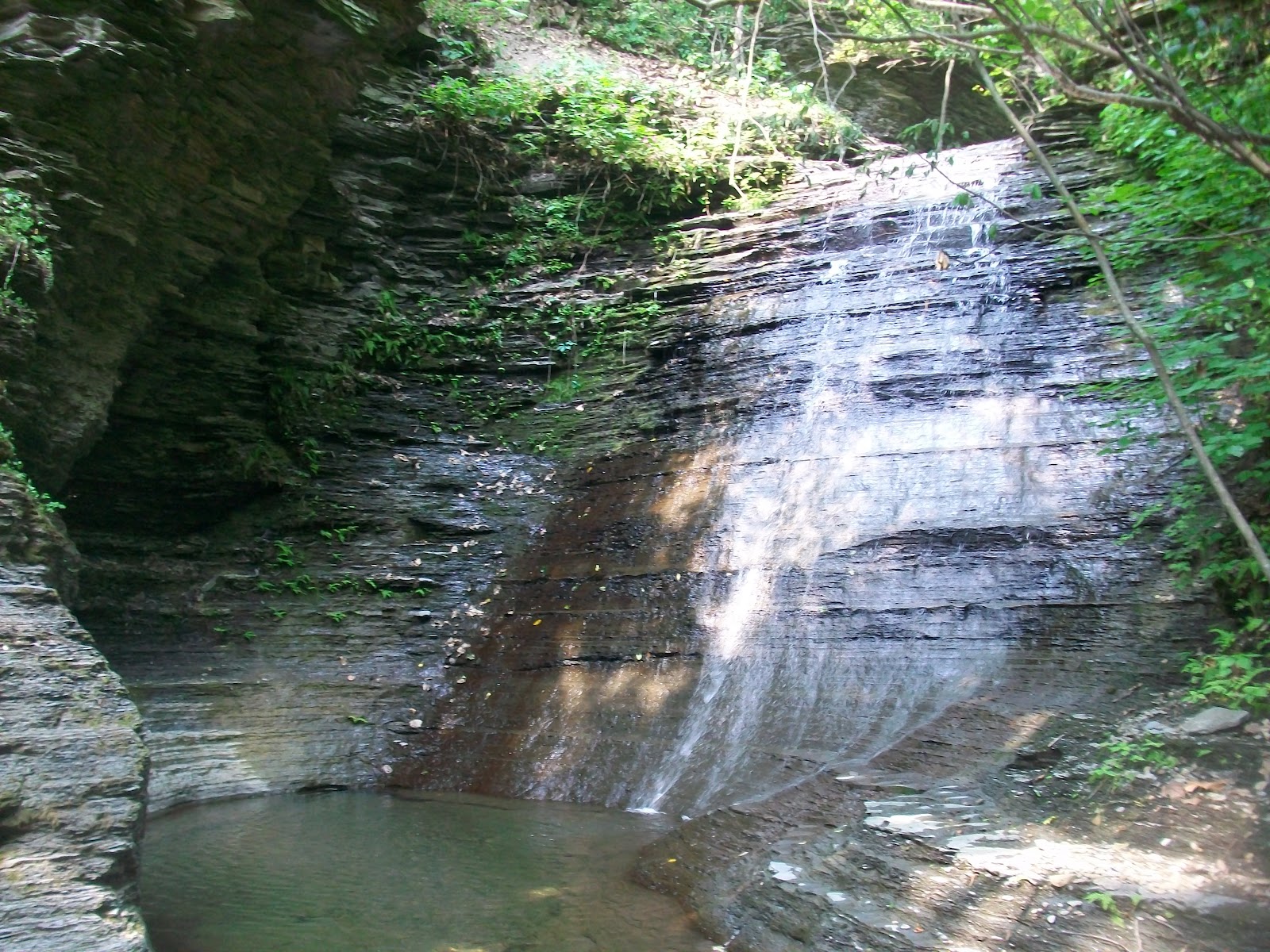
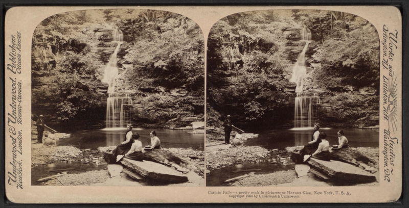
        Below are some stereoscopic images I have located in my research of the history of Havana glen. This post is meant to augment my previous post showing Havana glen as it currently is. I would assume that the images shown here were taken sometime between the late 1880s and mid 1910s. I assume the images themselves are within the public domain, although the scans of the images were retrieved elsewhere on the internet. I am not familiar with the copyright laws regarding these images. If you feel I have violated the copyright let me know and I will remove the offending image(s).

    I find it interesting to view the changes that have occurred in the glen in the past 150 years. And there is very little solid information about the history of the glen. So I have compiled what I could find in an attempt to educate people of its history. The story actually begins with the Native Americans who lived in the area at the base of the glen. There is the remains of what appears to be a ceremonial mound of sorts. This mound is located within the campground and has a concrete slab atop it for games. It is slowly getting worn away from campers. They used the council chamber above eagle cliff falls as a meeting place and in 1792 they were driven from the area. 

   More recent history has seen what was something of a resort type location. One report from the time talks of a fountain and croquet court. The glen was open for tourism during the late 1800s and early 1900s. I am unaware of when it was opened, or of when the rest of the glen was closed to the public. From my own research I have concluded that the original walkways of the glen were of wood. These may have been replaced every year due to flooding I do not know. After these a more permanent set of walkways constructed of Iron supports driven into the rock probably with a wooden deck and steel cable or rope for railing. This was the walkway type that went through the whole of the glen. The most recent walk way which is the one there now consists of a wooden walk way which follows the path of one of the earlier trails. At one point the walk way connects to a metal stair and above this a trail with steel cable railing. This trail leads to the base of eagle cliff and no further.

   At one point I theorize that due to Watkins glen's popularity, Havana glen began to fall into disrepair and lack of upkeep of the rest of the walkways until a more recent time period when the glen was acquired by the town of Montour and became a municiple park with the addition of the current walkway. Today I fear that the park is in danger of being lost as a local treasure as the main attraction is  Eagle cliff and few people are even aware that there is more above. But I figured people may enjoy a small glimpse into the past that I have uncovered.

 Photos with a number have a corresponding modern photo at my other post featuring the current glen here .
(some photos are out of order, The site wont let me move them as I would like)
I have added a more in depth look at Eagle cliff and Curtain cascade here if you are interested.


(1)Portal Cascade
Bridge
(2)Bridge looking down
(3)Eagle Cliff falls
(4)In the council chamber looking toward falls.
Base of bridal veil falls (from top of curtain cascade)
Mountain Tunnel.
(6)Fairies cascade.
(7)Upper gorge looking down.
Echo falls.
(8)Glen chaos looking down towards whispering falls. 
(9)Whispering falls.
(5)Curtain cascade 
Council chamber looking in general direction of curtain cascade.
(5)Curtain cascade.
Main street in Havana